


Kuststigen Väjern - Tullboden
This stage of the Kuststigen between Väjern and Tullboden, which is also the stage 6 of the Soteleden, passes some of Bohuslän’s best examples of coastal heathland. You’ll hike through forests and occasionally by the sea.
Quick facts
Length: 13 km
Timing: around 4-5 hours
Difficulty: moderate
Terrain: forest paths and coastal roads, occasionally boggy and steep
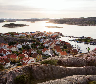
Fishing villages and giant’s cauldrons
This stage of the Kuststigen and Soteleden starts in the little fishing village of Väjern, one kilometre north of Kungshamn. After a short time you’ll come to two giant’s cauldron’s, “Dyrstolen” and “Predikstolen”. Giant’s cauldrons are potholes carved by meltwater into the rocks. They were created when eddies of water swirl round a collection of stones and gravel, that eventually ‘drill’ down into the bedrock. During the ice age many huge giant’s cauldron’s were formed, and you can often see the boulders that wore down the stone at the bottom of the cauldron, or nearby as unusually smooth, egg shaped stones.
Pretty heathland and nice swims
Håle Dalar, which you will pass, is a fantastic landscape, home to lots of nesting small birds. Near the ferry landing to Malmön is Bua heath, an area of natural beauty with an extensive coastal heathland and lovely beaches. The heath is on a sand deposit which makes the vegetation very susceptible to damage. Between the rocky headlands along the shore there are several swimming beaches, and from the tops you’ll get a magnificent view of the fjord and archipelago.
Fact about the trail
Length:
This stage is 13 kilometres.
Approximate times:
This stage takes around 4-5 hours to walk.
Marking:
This stretch is part of both the Kuststigen and the Soteleden. The Kuststigen is waymarked by name and in blue. The Soteleden is waymarked with blue/white marks on posts and trees and cairns in some places. There are good maps of the path (see more under Maps).
Level of difficulty:
The trail goes through varied terrain and is classed as moderate, but it can be boggy and steep in parts. At times you’ll be hiking along the coast but also through forests.
Start and end:
This stage starts in Väjern. There is a car park by Såtthagen football pitch. If you are travelling by bus get off at Väjern bus stop.
How to get here:
Väjern is a little village in the county of Sotenäs, just before Kungshamn and Smögen. It takes approximately 90 minutes to get there by car from Gothenburg, or by bus from Uddevalla (change at Halllinden). There are occasional direct buses from Gothenburg which take around 2 hours to get there.
Map:
A digital map of the trail can be found on Google Maps and the Sotenäs website. Map brochures can be purchased in, amongst other places, Tourist Information Centres in the area, and be downloaded from the Sotenäs website.
Sotenäs Turistinformation
Kommunhuset, Parkgatan 46 (sommartid: Ångbåtspiren)
45631 Kungshamn
Phone: +46523 665550
E-mail: info@sotenasturism.se
Website: To homepage


