


Hiking in Vänerstad
Vänersborg
Hike in Vänersborg - the gateway to Lake Vänern. With this hiking map you can discover popular destinations, beautiful nature areas and interesting history. Hiking in Vänerstad offers 10 kilometers of hiking in Vänersborg with the possibility to take longer paths if you want to see even more of what Vänersborg has to offer.
Quick facts
Length: 10 km
Time required: 2 and a half hours
Level of difficulty: medium
Terrain: city streets and nature paths in mostly flat terrain
Walk along the waters surrounding Vänersborg
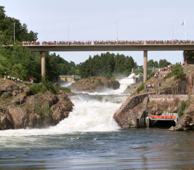
Vänersborg really is a city surrounded by water. To the north is Lake Vänern with its sandy beaches, cliffs and water so clean you can drink it. To the west is the Vassbotten bay, Karls grav canal to the south and the Göta River to the east. Here in Vänersborg, many leisure boats and cargo ships pass by travelling either north towards other ports in Lake Vänern or south towards the cities of Trollhättan, Lilla Edet and Gothenburg and then the sea. On their way they travel past many locks, one of them is located here in Vänersborg; Brinkebergskulle lock.
Birger Sjöberg, the city's most famous poet, gave his Vänersborg an exotic feeling when he named it Little Paris. The city stands on a rich history, from its foundation in 1644 until now when it is the regional capital of Västra Götaland County. Hiking in Vänerstad lets you explore the city of Vänersborg and the nearby areas that are rich in history and natural beauty, just by the shores of Sweden's largest lake.
Sights along the way
The hike begins at the old renovated train station building in central Vänersborg and you will start walking south, past the guest harbor and the beautiful work of art "Andarnas skepp" (The spirit's ship). You will walk along the park area next to Vassbotten bay before turning left and following the dug Karls grav channel where boat traffic travels on their way towards or from Lake Vänern. If you are lucky you will see one of the large cargo ships passing by. You can then decide if you want to follow the canal all the way to Brinkebergskulle lock or if you want to turn north through the outskirts of Vänersborg.
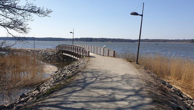
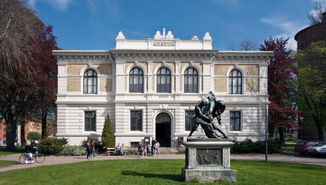
When walking north you will arrive at the beautiful Holmängen area, an untouched nature area just by the shores of Lake Vänern. Soon you will also arrive at Skräcklan Park, the most popular park in Vänersborg. Here you can pause your hike and take a swim in Lake Vänern from one of the several bathing spots. If you are here during summer you can also sit down and have something to eat at the Skräcklestugan cafe. At the park you can see the poet Birger Sjöberg's muse Frida looking out over the waters towards Dalbobergen Nature Reserve, where Birger Sjöberg and his friends often visited. The walk ends along the so-called Kulturaxeln (the Culture axis) where you can see the old Residence, the main square, the park Plantaget, Vänersborg church and a little further away; Vänersborg museum - Sweden's oldest preserved museum environment.
If you want to see even more
The Hiking in Vänerstad map offers even more for you to discover in Vänersborg. There are several extra paths you can take to see more of the area. For example you can see Nygårdsängen by Vassbotten bay, a valuable wetland area and if you follow Karls grav canal you can visit Brinkebergskulle lock. After visiting Brinkebergskulle lock you can visit the Restad Gård area that has a sculpture park, many walking paths along the Göta River and nice picnic areas. There is also Lillån nature area to the north.
Fact about the trail
Length:
The main path of Hiking in Vänerstad is about 10 km.
Approximate times:
The main hike takes little more than two and a half hours to hike without stopping.
Marking:
Signs with the logotype of Vandring i Vänerstad (Hiking in Vänerstad) and arrows show the way.
Level of difficulty:
The trail is mostly in urban areas on paved or well-trodden paths. Some areas like Lillån and Holmängen has more nature paths.
Start and end:
Start the hike wherever you want in the center of Vänersborg, two suggestions are at the train station or outside the Tourist Information Center by the main square. There are good parking areas close by such as Sanden where you can park for 48 hours for free.
How to get here:
If you come here by train or bus, the train station is a good starting point where you can directly follow the water south and get on the hike. If you come by car, you can park at Sanden, for example, then cross the Residence Bridge and turn right and you are on the trail.
Map:
A digital map of the trail can be found on Google Maps.
If you would like a printed map, it is available to for purchase at Vänersborg's Tourist Information Center for only 20 SEK. The information in the broschure is only available in Swedish. If you want a digital version you can download it here for free.
Visit Trollhättan Vänersborg AB
Kungsgatan 9
462 33 Vänersborg
Phone: +46 521 135 09
E-mail: info@visittv.se
Website: visittv.se

