


Edsvidsleden
Trollhättan
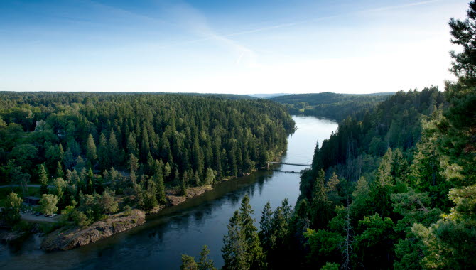
Edsvidsleden is a hiking trail in the beautiful Älvrummet Nature Reserve, not far from the centre of Trollhättan. The trail is 14 kilometres long and offers beautiful surroundings along the blue ribbon of the Göta älv river; magnificent views, open meadows and spruce forest filled with wild blueberry. The Edsvidsleden runs partly over hilly terrain and along the trail there are several places for fika breaks as well as public barbecue areas and windbreaks.
Quick Facts
Length: 14km
Time: 3.5 hours
Difficulty: Medium
Terrain: Nature trail, stairs and small forest roads, uneven terrain for some stretches
Scenic hiking close to the city
The Edsvidsleden trail in Trollhättan offers 14 kilometres of hiking with a great variety of landscape. The trail is also close to the city, making it easy to reach and popular with locals and visitors. It’s a high quality trail, perfect for all abilities to get some outdoor exercise in a beautiful location.
For an average hiker, the Edsvidsleden is an enjoyable day hike that takes about 3.5 hours without stopping, but of course we recommend you take lots of pauses and enjoy the magnificent surroundings, sit down for some well-deserved fika, or take the opportunity to pick berries along the way.
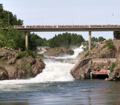
Start at Olidans Kraftstation and take the suspension bridge across the river
We recommend that you start your walk at the car park opposite Olidans Kraftstation (Olidan's Power Station) beside the Göta Älv river. After crossing the suspension bridge, turn left onto the trail and off you go! You follow the water for most of the first section, which winds in and out of the dense forest. If you are interested in fishing, there are several fine fishing spots where you can try your luck (fishing licenses for the river can be bought at the tourist office which one?).
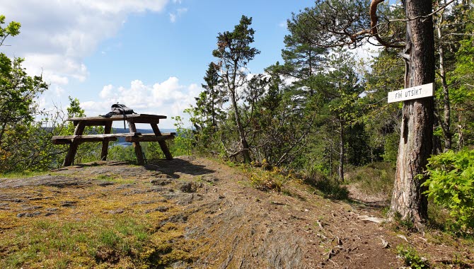
Two places that you can look forward to are Nyckelberget (Key Mountain) and Kopparklinten (Copper Cliff) – you reach the former after about three kilometers and Nyckelberget welcomes you with an open view of the valley where you can glimpse the river as it winds its way towards Gothenburg. There are picnic tables and benches so you can enjoy the view with a reviving cup of coffee.
Photographer: Lina Katana
A treasure chest of untouched nature
There is a lot to see along the Edsvidsleden; if you’re interested in nature the trail is a treasure chest filled with a rich biodiversity, historic landscapes, and tranquil places to sit and rest. You pass through no less than two nature reserves along the Edsvidsleden: Älvrummet and Åkerström. The first after you cross the suspension bridge at the start and the second just south of Nyckelberget. From here, the hike then goes inland along paths through fairy-tail forest and alongside pastures and meadows. The terrain is hilly in places.
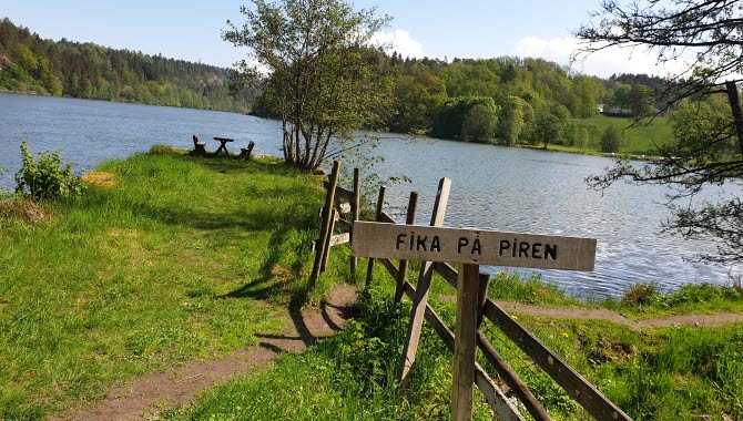
Along the trail there are several places that are excellent for a fika break. Sit down and recharge at some rapids, at one of the lookout points or along the path at one of picnic benches. If you bring something to grill with you, you can use the barbecue areas, one of which has a roof. Firewood is provided. About halfway along the trail is a windbreak if you want to take a slightly longer break.
Finish with Trollhättan's finest view
Towards the end of the hike you meet the city again at the old neighbourhood of Strömslund with attractive villas lining the streets. If you take a detour you can see some traditional wooden architecture in the streets around Slaskegatan and at Forngården the collection of historic buildings will give you an insight into what life was like in rural Sweden.
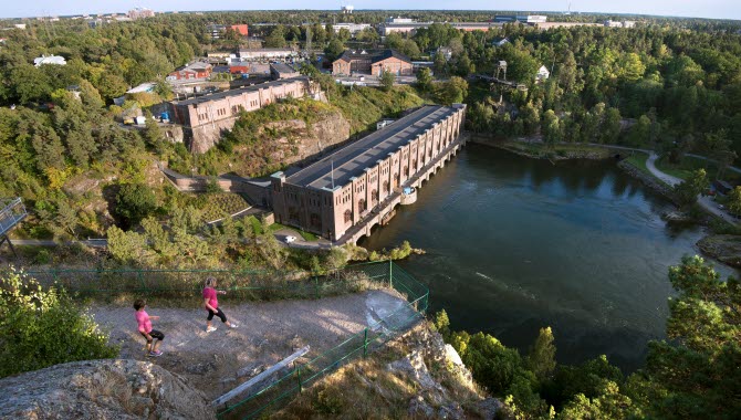
Finish by walking up Kopparklinten to get a staggering view of Trollhättan. South towards Göta älv you can see the car park and the suspension bridge where you started. During World War II, the Copper Cliff served as a stronghold for anti-aircraft guns defending Olidan's Power Station. Today the viewpoint is a popular destination for visitors and locals.
Photographer: Roger Lärk
Photographer: BildIT
Stay an extra day?
If you want to stay overnight in Trollhättan there is plenty of accommodation to choose from. Albert Kök Hotell & Konferens has good hiking packages. Scandic Swania and Hotel Bele are located near the trail. And while you are still here you could take the opportunity to visit the mighty Trollhätte Falls or the Saab Car Museum.
Fact about the trail
Length:
Edsvidsleden is 14km.
Sections:
- Olidestationen - Åkerström: 3.8 km
- Åkerström - Svenäcker: 3.9 km
- Svenäcker - Olidestationen: 5.6 km
Approximate times:
The whole trail takes about 3.5 hours without stops.
Marking:
Along the trail there are black and white square-shaped markings in the forest areas. In Strömslund district there are also white arrows with a black background in some places.
The City of Trollhättan manages and maintains the trail. If you have anything to report, please contact the City of Trollhättan.
Level of difficulty:
The trail runs partly over hilly terrain in forest, over small bridges, boardwalks, and stairs. The trail has been graded as medium level of difficulty. The trail is not suitable for prams or wheelchairs.
Start and end:
The recommended start and finish is at the car park opposite Olidans Kraftstation (Olidans Power Station). There is free parking and the trail starts about 250 meters from the parking lot on the other side of the suspension bridge. After the suspension bridge turn left and you are on the Edsvidsleden. It is of course possible to start the hike anywhere along the trail.
How to get here:
On foot or by car
Starting from Drottningtorget in Trollhättan, it is about 2.5 km by car or on foot to the car park opposite Olidan's Power Station. Pass Drottningtorget along Torggatan towards Klaffbron and Göta älv. Turn left just after the bridge and follow Åkersbergsvägen past Trollhättan's church and Insikten. Then turn right down Olidevägen and follow it until you reach the car park.
Public transport
If you want to take public transport from either the Trollhättan travel center or Drottningtorget, you can take bus 21 towards Skoftebyn. Get off at the Trollhättan Innovatum stop and go right at the roundabout. You will pass Nova Mat och Möten restaurant, Innovatum Science Center, and Saab Car Museum. Then cross the Olidebron Bridge and follow Kyrkobrovägen which becomes Åkersbergsvägen and then turn right onto Olidevägen. It is about 1.1 km to the car park from the bus stop.
Map:
For a digital map of the trail visit: Google Maps.
There is also a printed map that is available free of charge from the Trollhättan or Vänersborg tourist offices. The map can also be downloaded as a pdf here.
Visit Trollhättan Vänersborg AB
Drottningtorget 1
461 30 Trollhättan
Phone: +46 520 135 09
E-mail: info@visittv.se
Website: visittv.se


