

Eggvena hikingtrails
Eggvena, Herrljunga
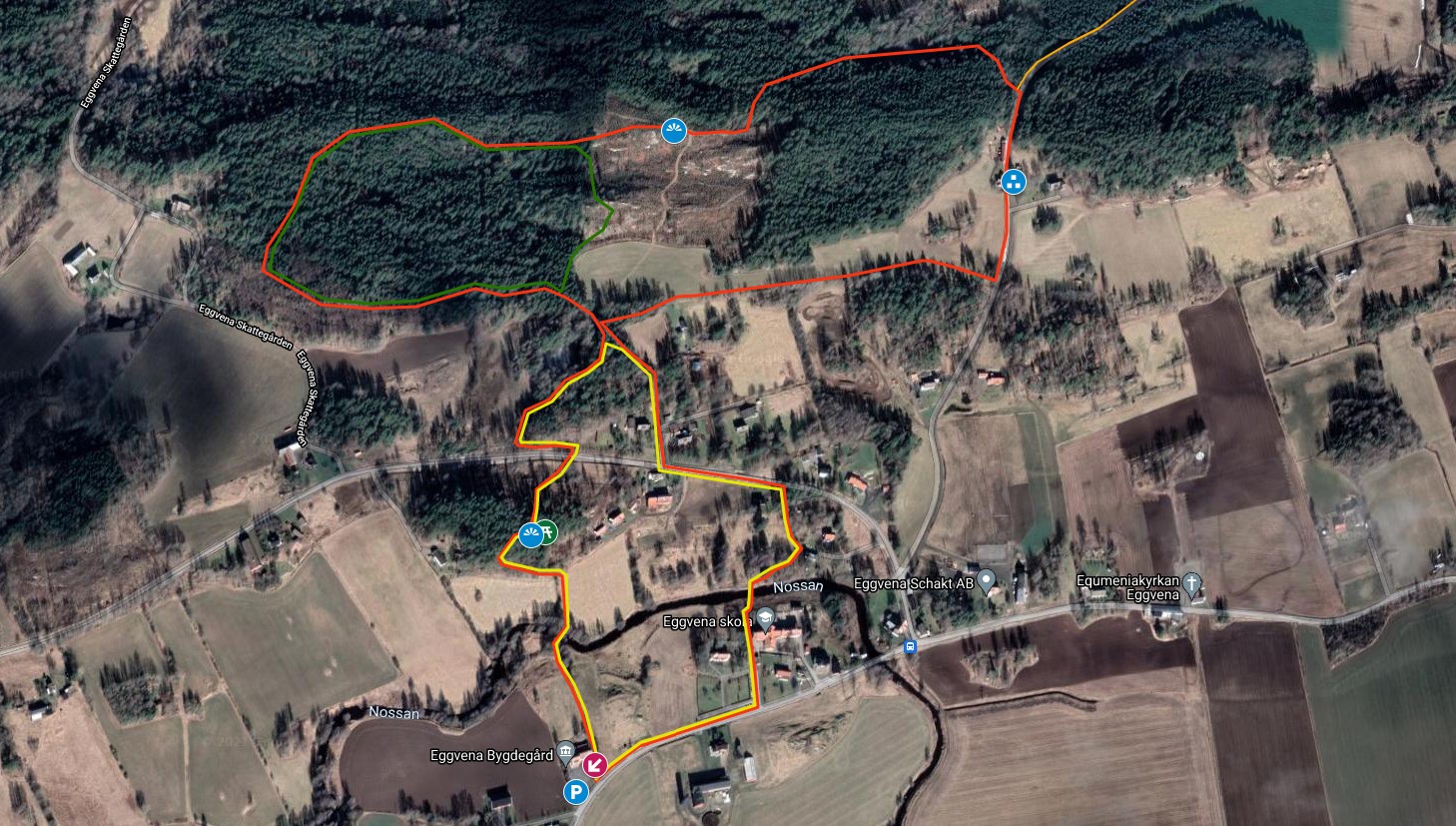
Welcome to hike the the trils in Eggvena. There are three different trails that offer shorter walks in a varied nature in a beautiful cultural landscape.
Red trail: approx. 4 km
Yellow trail: approx. 1.6 km
Green trail: approx. 1.1 km
Time required: Calculate approximately 1 hour for the Red Trail at a slow walking pace, the other trails a slightly shorter time.
Difficulty: Moderate
Terrain: Mostly forest paths and gravel roads, shorter sections on asphalt
Trail marking: Red, yellow and green markings
Eggvenalederna
The Eggvenalederna offers scenic hiking in varied nature.
The red and yellow trails have their starting point at Eggvena village farm.
The Green trail is reached via these trails and merges with the yellow and red trails, respectively.
From Eggvena Bygdegård you pass via a bridge over Nossan and walk in surroundings with most of the cultural remains such as croft grounds in Nossan's valley.
At Långfredagsberget (Long fridayhill) nearly a kilometer after Eggvena bygdegård there is a place where you can look out over Nossan's valley, Here you find a small picnic table to sit down for a break. There are some trees grown up so you have walk to the edge of the hill to see the view.
Map for printing / download can be found at the bottom of the text.
Fact about the trail
Length:
Eggvena Red trail ca. 4 km
Eggvena Yellow trail ca. 1.6 km
Eggvena Gren trial approx. 1.1km
Approximate times:
At a leisurely pace, the
Red trail takes approx. 1 hour to walk
Yellow trail approx. 20-30 minutes
Gröna trail approx. 15-20 minutes
Area:
The Eggvena trails mostly run in the forest by the small community Eggvena. The area is interesting from a cultural-historical point of view and the fine older church is worth a visit, if you are lucky you may pass one day when the church is open. A runestone is located on the south side of the church.
Just west of the church is Eggvena primary and middle school.
Along the trails there are several croft grounds and places with history that associations in the area have put up.
Nossan flows through Eggvena and with a walk along yellow and red trails you pass Nossan over two walking bridges.
A few hundred meters south of Eggvena village there is a stately runestone placed along the road to Bråttensby. Well worth an extra trip for the interested.
The landscape in Eggvena is varied. South of the river Nossan, a countryside with farmingfields spreads out. North of Nossan, the forest takes over with some elevations in the landscape, which occasionally offers a nice view of Nossan's valley. Parts of the forest were once part of the large crown park Edsweden dating from the 13th century and which was the king's forest and an area with large oak forests. Today it is mostly coniferous forest and mixed forest with elements of oak in the area.
Along Jämnesjövägen where the red trail runs, there is a boundary stone preserved that marks Edsweden. There are more stones in the former Kronoparken which is dated 1695. Edsweden kronopark stretched from Södra Härene in the east to the area around Larv in the west.
Think about:
The area is partly hilly and some places can be wet during certain seasons and periods, so during rainy periods it can be good to wear sturdy shoes or hiking boots. The trails are not pram friendly, as the trails occasionally follow smaller paths.
Marking:
Green, yellow and red markings mostly on poles along the trails. Pay extra attention in the areas where the trails meet so you continue to follow the planned trail and it is good to download a map and have it in your mobile or to take a photo or take a screenshot of the map..
The green trail starts a bit along the red trail and they joins partly of the walk. Pay attention if you follow the green trail that it deviates from the red trail and goes back down a slope up at the northern ridge of the red trail.
Level of difficulty:
Moderate
Suitable for:
Those who want to go for a shorter hike and are suitable for both adults and children. Associations in the area have put up some signs along the trail that tell about cultural history and signs that show croft grounds.
Start and end:
Start and finish at Eggvena Bygdegård. The trails can also be combined with the trail Seven Lakes Trail. Between the red trail and the Seven Lakes trail,you can walk along Jämnesjövägen on a stretch of about 2 km that allows you to combine these trails.
Parking is available at Eggvena Bygdegården
How to get here:
Direction from Herrljunga
From Herrljunga Railwaystation
Drive left onto Storgatan towards Alingsåsvägen approx. 200 m
Turn right to Alingsåsvägen / road 181 approx 260 m
Turn right to Bitterna road, follow the road approx 1.3 km
Turn left to Vretavägen and follow this road approx 7.5 km
Eggvena Bygdegård is located along the road west of Eggvena church.
Map:
Maps:
Map that you can open below can be printed or downloaded from google but a tip is that if you have a smartphone / mobile phone. take a screenshot of the map and save it to your mobile phone.
Click on the Google map below and it will open in a new window.
In Herrljunga GISmaps you also can follow the trail.
Follov this ling Eggvena trails GIS for to opend the GIS site
Red trail: approx. 4 km
Yellow trail: approx. 1.6 km
Green trail: approx. 1.1 km
Time required: Calculate approximately 1 hour for the Red Trail at a slow walking pace, the other trails a slightly shorter time.
Difficulty: Moderate
Terrain: Mostly forest paths and gravel roads, shorter sections on asphalt
Trail marking: Red, yellow and green markings