
Hiking trails in Uddevalla
Experience nature in Uddevalla on foot. Enjoy salty baths, magnificent views and beautiful wooded areas along your way.
STRANDPROMENADEN
Uddevalla's pride with its spectacular wooden deck creeping around the steep rock walls along the sea line. An obvious excursion destination!
The beach promenade, especially the stretch Svenskholmen-Skeppsviken-Gustafsberg-Lindesnäs, has become the pride of the people of Uddevalla. In 2009, it was also named Sweden's most beautiful road by the Swedish Road Administration and was awarded the Beautiful Roads Prize!
During a walk along the entire Strandpromenaden, Uddevalla's history passes revue. At the point of departure, the Shell banks are remnants from the Stone Age settlements and the banks are unique fossil remains from the last ice age about 10,000 years ago. The trail continues along Bäveån through the idyllic Regiment Park and past Bohuslän's Defense Museum.
The beach promenade cuts through the district of Tureborg, which is named after the castle Ture Malmgren had built nearby. A lookout tower remains of the castle, but Ture's romantic home Villa Elfkullen remains on a hill by the river. The road continues down towards Vadbacken and through the park area Hasselbacken where the city church sits and follows the old harbor canal through the center to the Bäveån outlet. On the north side of the quay is Bohuslän's museum.
The beach promenade continues on the south side towards Skeppsviken where you walk on the spectacular wooden deck, which is anchored in the rock wall on one side. The bathing area at Bodele and the open-air bath Landbadet are passed before arriving at Gustafsberg, Sweden's oldest seaside resort, which is reminiscent of seaside resort life from bygone times. Now only a short distance remains along the Byfjord and the beautiful summer villas from the end of the 19th century before the goal is reached in Lindesnäs.
Length: 9 km.
Time: About 3 hours without breaks.
Marking: Light blue signage is available all the way.
Surface: Gravel, asphalt and forest paths.
HIKING TRAIL "JORDEN RUNT"
Nature experience with sky, sea, mountains and valleys.
Take an invigorating walk on the hiking trail "Around the world" on Gustafsberg.
The loop is marked with bollards with a white top. It is 5.5 km and is designed so that you decide how far you want to walk, in the middle of the loop is Gustafsbergsparken.
"Around the world" is a nature experience with sky, sea, mountains and valleys. The health source is available at certain times, then take the opportunity to quench your thirst by "drinking well" and becoming part of a 300-year-old tradition.
Length: 5.5 km
Time required: about 2 hours
Difficulty: medium
Terrain: partly hilly
THE SHELL TRIANGLE
A loop through three nature reserves.
The seashell triangle is a hiking trail that takes you between three of the areas in Uddevalla where seashell banks are found: Kuröd, Ramseröd and Älje Porsen.
The trail takes you on a journey through time, beginning about 10,000 years ago when the banks were created, until the beginning of the 20th century when the gravel was exploited and created an industry that came to shape Uddevalla in many ways. The gravel in the ground has given all three areas interesting flora and fauna with high nature values and they are therefore also nature reserves.
Inspiration for the joint marking comes from the sacks in which the seashells were packed. These were adorned with a similar snail and the color of the ribbon is taken from the color of the sack.
To find the trail you can cycle to the Skalbanksmuseet in Kuröd, take the bus to the stops Nordverk, Nöthult, Gräskärr or Glimmingen, drive and park at the Skalbanksmuseet, Ramseröds nature reserve or at Älje-Porsens nature reserve.
Length: About 16 km.
The path is quite hilly.
Time: About 4-5 hours without breaks.
Marking: Beige ribbons and stickers with the seashell triangle symbol.
Surface: Forest paths, gravel roads and asphalt.
VINDSVALAN
Exercise tracks in Uddevalla.
Up in the forests at Kapelle you can find this nice exercise track where you can walk or run in the slightly hilly track while you get a really nice experience in nature.
This is an appreciated trail that is located near Uddevalla so it is great to get to a sunny afternoon to enjoy the forest. Maybe you can see and hear Uddevalla's symbolic raven, as it thrives in the immediate area?
The track is gravelly but is not illuminated so it is best suited during the bright hours of the day. Welcome to another of Uddevalla's beautiful urban areas close to the city!
By bike you can reach Vindsvalan either via Sigelhults cemetery, Lindåsvägen or Bratterödsvägen. If you go up to Bratterödsvägen, you have to prepare for a proper uphill on the way up to Kapelle. Signs can be sparse, so bring the map as support.
To pick up the car, drive towards Kapelle and Emaus. Then follow Bratterödsvägen and you will reach the car park after about 2 km.
Length: About 4.2 km. The track is slightly hilly.
Time: About 1-1.5 hours without breaks.
Marking: There is no marking along the road but there are signposts to facilitate.
Surface: Gravel and forest path
TURESTIGEN
A section with a distinct theme: Ture!
The path is a circular loop and starts and ends in the same place. The path leads you from the residential area Tureborg via the ruins of Tureborg and into the Ture dalar nature reserve.
Up by the ruin you can see the remains of Ture Malmgren's magnificent castle which he had built in the early 20th century with medieval castles as inspiration. The trail also goes through the magic the brook ravine that forms the nature reserve Ture dalar. The nature reserve has a dramatic terrain with moss-covered rocks in a rustling deciduous forest.
The trail is marked with red markings and is a circular loop of about 2 km, however, some passages are quite steep and can be experienced as difficult. To get to the area it is possible to cycle to end of the road Dalgången to get straight to the start of the trail. If you take a car, you can park at the tenniscourts along the road Dalstigen, from there it is about 400 meters up to the loop.
Length: About 2 km. The path is quite hilly.
Time: About 45 minutes without breaks.
Marking: Red ribbons and red markings.
Surface: Forest paths, gravel and rocks.
EGONSPÅRET
Beautiful and dramatic.
Along Brattåsbäcken you will find this beautiful and dramatic walking and exercise track.
The four-kilometer-long Egon Trail runs around the lower part of the brook. Walk on the sometimes steep ridges and enjoy the varied grove and coniferous forest and the beautiful giant spruces. After the shooting range at Bulid, you pass a waterfall and the remains of an old mill.
The flora and fauna are rich, with forest bream, marsh fibula and gold powder, rapeseed, currents and lesser woodpeckers. The Egon track, which is based on Uddevalla Orienteering Club's cabin, is named after Egon Johansson, who was injured when he worked on completing the track in the mid-1990s.
The slopes on each side of the bridge over Brattåsbäcken have been named Håkan's slopes, in the spring of 2019, to honor the memory of our very prematurely deceased club member Håkan Flingmark. Egonspåret is maintained by Uddevalla Orienteeringsklubb and the responsibility is distributed uniformly. Maintenance of precisely these slopes was Håkan's assigned responsibility. A responsibility he took very seriously and with a lot of care and therefore there is no more suitable name for this stretch on Egonspåret than Håkan's slopes.
Length: About 4 km. The path is quite hilly.
Time: About 60 minutes without breaks.
Marking: Red ribbons and red markings.
Surface: Forest paths and gravel.
HERRESTADSFJÄLLET
A clear favorite for hiking, climbing and fishing.
Herrestadsfjället is a clear favorite to visit, whether you want to hike, climb, cross-country ski, seek fishing happiness or just enjoy the inviting nature.
The forest area has a large element of rocky terrain, bogs and lakes. The older forest of the reserve has an age of 100 to 130 years. Many hiking trails run through the area and the mountain is a popular destination for both hiking and climbing as well as cross-country skiing, but many fishermen also go here - precious fish have been planted in some lakes. Beware - fishing license needed!
A more detailed map from Uddevalla Orienteering Club can be purchased at Uddevalla Tourist Center.
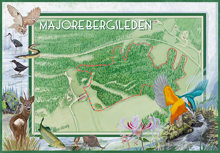
MAJOREBERGLEDEN
A lush rainforest-like valley.
Do you want to experience a lush rainforest-like valley with lots of blooming white sedges where, with a bit of luck, you can also see beavers, kingfishers and migrating sea trout?
The hiking trail winds its way through wonderful nature, past babbling brooks and roaring waterfalls, it is easily accessible and an exciting excursion destination for the whole family.
The trail consists of an easy-to-walk gravel walkway of 700 meters to the first barbecue area. You can go there with the whole family. After that the trail has the character of a natural hiking trail with both enveloping greenery and expansive views, here it is a bit more challenging.
The Majorebergsleden starts at Majoreberg, which is located by the road that goes up to Klämman on Herrestadsfjället. The trail runs in a wide circle and it starts and ends at the barn building on Majorebergsvägen, well marked with signs.
Length: 3.5 km. The path is quite hilly.
Time: Approximately 60 minutes.
Marking: Signs.
Surface: Forest paths and gravel. In periods of and after rainfall, parts of the trail can be very muddy and thus slippery in some parts and more difficult to walk.