Strandpromenaden
Grundsund, Skaftö
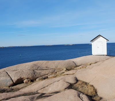
A private donation to Skaftö Öråd has made it possible to build a hiking trail to Vigerna. Welcome to walk on the wooden deck between two bathing areas overlooking the fairway and the archipelago.
Quick facts
Length: 750 m
Timing: 10 min
Difficulty: Moderate
Terrain: Wooden footbridges, steps and a short nature trail
Skäddhålan
Thanks to the association Skäddhålans Vänner and a number of donors, you can walk out of the harbour from Östra Kajen in Grundsund on the wooden deck along the rocky coastline all the way to the bathing area Skäddhålan. There is a changing cabin, a sun deck and a barbecue area. Along the walk there are several benches to sit on and several ladders to reach down to the water. The wooden deck to Skäddhålan is adapted for diasabled.
Strandpromenaden continues
From Skäddhålan all the way to the bathing area at Vigerna, the beautiful Strandpromenaden continues, first with a steep staircase up along the rocky mountain, before winding further along the coastline. Along the way there are several benches to sit down for a rest, feel the salty wind or just admire the view of the archipelago. High up in the steep rock wall is a cave. Along the trail there are a couple of information signs about the landscape with further reading through QR codes.
Vigerna
Strandpromenaden ends at Vigerna, which is a popular bathing area. From there you can continue the road forward and at the next crossroads turn left onto the Munkevik hiking trail or walk up back towards Grundsund.
Fact about the trail
Length:
750 metres
Approximate times:
10 minutes
Marking:
A long wooden deck with wooden steps along the rocky coastline
Level of difficulty:
From Grundsund it is easy to reach Skäddhålan with a weelchair or a pram on the wooden boardwalk. From Skäddhålan there is a steep climb on wooden steps but they are easy to walk.
Start and end:
Start from Östra kajen in Grundsund.
End at Vigerna bathing area.
From Vigerna bathing area, you can either turn around and take the same road back or continue up Vigernavägen and come back into Grundsund. You can also walk up to the crossroads with the wooden sign Munkeviksleden and continue Munkevik hiking trail which leads on to Stockevik and Fiskebäckskil.
How to get here:
Parking spaces in Grundsund is scarce during summer. Park at Bottnahallen or get off the bus (Västtrafik 845) in Grundsund and walk 10 minutes down to Östra kajen.
Map:
You can find a route map on Google maps and if you want a printed map, it is available at Infopoints in Lysekil municipality.
If you are interested in more scenic hikes on Skaftö - check out Skaftö – en livslång kärlek with a map which is also printable.


